
Parcel 04-1N-23-0000-0001-0000
Owners
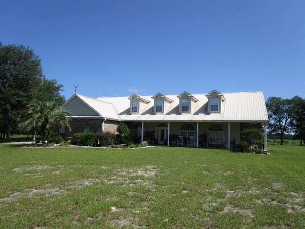
18220 HOOT OWL HOLLOW
HILLIARD, FL 32046
Parcel Summary
| Situs Address | 18220 HOOT OWL HOLW |
|---|---|
| Use Code | 5901: HARDWOOD SI 70-79 |
| Tax District | 6: Drainage Dist |
| Acreage | 26.480 |
| Section | 4 |
| Township | 1N |
| Range | 23E |
| Subdivision | |
| Exemptions | HX: Homestead (196.031(1)(a)) (100%) HB: Homestead Banded (196.031(1)(ab) (100%) |
Short Legal
PT GOVT LOTS 1 & 2 OFSEC 4-1N-23E IN OR 1036/155
(EX PT IN OR 994/276,...
Values
| 2025 Certified Values | 2026 Preliminary Values | |
|---|---|---|
| Land Value * | $53,082 | $20,611 |
| (+) Improved Value | $635,806 | $626,730 |
| (=) Market Value | $1,042,466 | $964,145 |
| (-) Agricultural Classification | $6,457 | $5,986 |
| (-) SOH or Non-Hx* Capped Savings ** | $384,410 | $335,287 |
| (=) School Assessed Value | $304,478 | $337,054 |
| County Assessed Value | $304,478 | $312,054 |
| (-) School Exemptions | $25,000 | $50,000 |
| (-) Non-school Exemptions | $50,722 | $51,411 |
| (=) School Taxable Value *** | $279,478 | $287,054 |
| (=) County Taxable Value | $253,756 | $260,643 |
Document/Transfer/Sales History
| Instrument / Official Record | Date | Q/U | V/I | Sale Price | Grantor | Grantee |
|---|---|---|---|---|---|---|
| WD 1036/0155 | 2002-01-28 | Q | Vacant | $105,000 | TANNER IRIS BRADDOCK | ALDERMAN MARK D SR & KAREN C (H&W) |
| FJ 0753/1567 | 1996-03-07 | U | Improved | $100 | NASSAU CLERK OF COURT | TANNER IRIS BRADDOCK |
| QC 0680/0920 | 1993-05-10 | Q | Vacant | $100 | CRAWFORD O B | DURHAM DOROTHY ETAL |
| PR 0576/0956 | 1989-05-18 | Q | Vacant | $100 | TANNER IRIS BRADDOCK AS PR OF CRAWFORD ADDIE M EST | TANNER IRIS BRADDOCK |
Buildings
Building # 1
| Heated Sq Ft | Year Built | Value |
|---|---|---|
| 2494 | 2007 | $610,393 |
Structural Elements
| Type | Description | Code | Details |
|---|---|---|---|
| EW | Exterior Wall | 20 | FACE BRICK |
| EW | Exterior Wall | 05 | AVERAGE |
| RS | Roof Structure | 08 | IRREGULAR |
| RC | Roof Cover | 12 | MODULAR MT |
| IW | Interior Wall | 05 | DRYWALL |
| IF | Interior Flooring | 11 | CLAY TILE |
| AC | Air Conditioning | 03 | CENTRAL |
| HT | Heating Type | 04 | AIR DUCTED |
| BDR | Bedrooms | 3.00 | |
| BTH | Bathrooms | 3.00 | |
| FR | Frame | 02 | WOOD FRAME |
| STR | Stories | 1.5 | 1.5 |
Extra Features
Land Lines
| Code | Description | Zone | Front | Depth | Units | Rate/Unit | Acreage | Total Adj | Value |
|---|---|---|---|---|---|---|---|---|---|
| 005000 | AGRICULTURAL HOMESITE | OR | .00 | .00 | 1.00 | $13,000.00/AC | 1.00 | 1.00 | $13,000 |
| 009530 | POND | OR | .00 | .00 | 0.65 | $2,500.00/AC | 0.65 | 1.00 | $1,625 |
| 006000 | PASTURE - HAY | OR | .00 | .00 | 6.00 | $370.00/AC | 6.00 | 1.00 | $2,220 |
| 005901 | HARDWOOD SI 70-79 | OR | .00 | .00 | 18.83 | $200.00/AC | 18.83 | 1.00 | $3,766 |
| 009910 | MARKET VALUE AGRICULTURAL | OR | .00 | .00 | 24.83 | $13,000.00/AC | 24.83 | 1.00 | $322,790 |
Personal Property
None
TRIM Notices
Property Record Cards
Disclaimer
The Nassau County Property Appraiser's Office makes every effort to produce the most accurate information possible. No warranties, expressed or implied, are provided for the data herein, its use or interpretation. The information contained herein is for ad valorem tax assessment purposes only. The Property Appraiser exercises strict auditing procedures to ensure validity of any transaction received and posted by this office but cannot be responsible for errors or omissions in the information received from external sources. Due to the elapsed time between transactions in the marketplace, and the time that those transactions are received from the public and/or other jurisdictions, some transactions will not be reflected.